Route planning is an important skill to master for people who enjoy riding far because most of them do so partly because they want to see new regions and places. In addition, some bikepacking races like the Transcontinental Race involve the additional challenge of finding the optimal route between checkpoints.
Page Contents:
General Route Planning
Part of the preparation for doing The Transcontinental Race is deciding what route to use to cross Europe while visiting all of the checkpoints. This is a massive task and it’s easy to underestimate how much time it will take, so you should start the process as early as possible. Many people who rush their route planning often regret doing so once they are on the road and experiencing routing problems that could have been avoided.
Some people are better at route planning than others, but everyone can become a better route planner by making it part of their training. Do some rides in areas that you don’t know, maybe take a train to start further from home than normal, plan a route beforehand and see how well it works out. Did you have problems following the route? Were the choices you made when planning the route what you actually wanted to ride when you got there? During those rides, have the Navigation Devices that you will use during the race to ensure that you’re familiar with all of its functions and to discover which navigation methods work best for you.
Basic Routing
When starting to plan your route, you should break it down into more manageable pieces by concentrating on a single section between two checkpoints at a time. Then make a very general plan for each section and only get into the details of specific roads once you’ve decided on the general route.

Google Maps can be a useful tool in the early stages of route planning. You can ask Google for a driving route and select Avoid Highways from the drop-down Route Options menu, then drag parts of the route around to get an idea of what distances are involved in certain options. Paper maps can also be useful for general route planning because they are often better than online maps at showing which roads are the major ones and which are the most important towns in each region.
The amount of elevation gain on each route option can be as important as is the distance. Unfortunately, Google Maps doesn’t give this information, but good quality paper maps often show the elevation of each major climb or you can put your mouse pointer over any location in Google Earth and it will give you the elevation in the bottom-right of the screen. Once you get into more detailed planning, you’ll probably use mapping tools that give detailed elevation profiles, but I normally don’t use such tools for the earlier stages of planning.
Sometimes, Google Maps won’t let you use a certain road, particularly smaller mountain passes. This is often because the pass is closed for several months of the year, but you don’t need to worry about that since races are normally held in the middle of summer.
While doing the general planning, you should explore wildly different route alternatives that may pass through completely different regions or even countries. Look at longer, flatter options as well as shorter, but hillier ones. If certain ferries are allowed, look at what the route with and without using the ferry would be like. In general, try to get a rough idea of all reasonable possibilities before looking at any in more detail.
![]()
The TCR has sometimes used the same checkpoints in multiple race editions, so sometimes routes used by riders in previous years can be useful to at least show you what possibilities exist, even though it won’t tell you which is the best option (see map on the right). Maps showing the checkpoints for each race edition and links to the tracker data are included in The Transcontinental Race pages.
Some people find that they get lonely when not seeing another rider for one or more days due to selecting an unusual route, so they would prefer to choose a route that maximizes the frequency with which they see other riders. This is not a major criterion for me, but if it is for you then consider always choosing the most obvious/natural route and roads available. You may enjoy the social interaction available on that route more than you’ll enjoy exploring a less obvious route.
You may decide that there are multiple very different route options that each have their own benefits. Fortunately, you don’t have to make all of your decisions at home. You can prepare multiple options and have them all ready on your navigation device and then choose one when you are there. This can be particularly useful if bad weather is forecast because you can choose between the options based on which has the better forecast (i.e., warmer, drier, or less headwinds).
Road Choice Criteria
Before starting to choose between different roads, you should consider which type of roads you prefer to ride on. In general, faster riders tend to use more major roads than slower riders, who tend to be more relaxed and more focused on enjoying the ride rather than being as fast as possible. The slower riders are therefore more likely to use smaller, quieter, and more scenic roads. However, in some regions there are no viable alternatives to the major roads and in other regions significant time can be saved by using some minor roads.
The type of terrain that you enjoy riding in and the type of cyclist that you are is also important. Do you prefer more direct but hillier routes or less direct and flatter routes?
Personally, I prefer to stay on minor roads during the daytime, but I often use more major roads when riding at night. At night-time you cannot see much of the scenery anyway, and the traffic on the major roads is reduced to a level where riding on them can be quite pleasant. Because it’s a lot easier to navigate when following the main roads, I often don’t need to have that version of the route saved on my GPS, I can just navigate via the main roads as I go along and just make sure that I don’t deviate too far from the line that shows the route that I originally planned.
Route Planning for Multiple Countries
Unfortunately, the skills and strategies that work well for a certain country when finding good roads to ride on don’t always transfer to another country. In some countries, even minor roads are perfectly maintained and are a pleasure to ride. In other countries, minor roads can be absolutely terrible, and sometimes even roads that are marked on maps as being quite major might actually be unpaved and in a terrible condition and so may be very slow to ride on.
How pleasant the more major roads are to ride on also varies a lot between countries. In some places, all major roads have a hard shoulder that is safe to ride on, but in other places even the major roads can be quite narrow, full of traffic, and so are quite stressful and dangerous to use.
Due to the number of countries that the TCR passes through, it’s hard to know what will be the best strategy everywhere, so do as much research as you can by reading reports from people who rode the race previously. Google Street View can also sometimes be used to get an idea of what a road is like.
Border Crossings
Crossing the border between countries is often where route choices are the most limited. When traveling in the Schengen Area of Europe (Wikipedia), you shouldn’t have any problems at any border crossings, and often you won’t even be sure exactly where the border is. Many countries in southeastern Europe are not part of the Schengen Agreement and so border controls still exist. You should check that you don’t need a visa to enter any countries that you will pass through and also check that the border crossings that you plan to use are open to everyone.
Some crossings on minor roads are only open to local residents, whereas those on major roads can be used by everyone. Many paper maps have different symbols for local versus universal border crossings and some countries have an online list of border crossings so that you can check the ones that you plan to use.
Several racers in previous editions of the TCR have reported having problems passing some smaller border controls. Some have had to take a major diversion while others have been allowed through by pleading with the border guards even though it wouldn’t normally be allowed. The race organizers have declared that they leave these decisions up to the border guards and will not give any penalties except if someone tries to avoid a border control by taking an off-road diversion through a field or woods to cross the border undetected and illegally.

Using Someone Else’s Route
Because route planning is such a big undertaking, and not everyone is skilled at it, some people are tempted to follow a route that someone else has prepared. This can work, but you should not do so without spending a lot of time studying the route.
If you use someone else’s route without studying it closely then you’ll have two major problems: First, a route planned by someone else will be optimized for a different set of criteria than you have in terms of road and terrain choices, so you may want to tweak the route in certain sections to better suit your preferences. Second, and more importantly, not spending the time to do the route planning will mean that if (when) things go wrong (e.g., your route takes you up a road that doesn’t exist, that turns into a rough track, that is closed due to construction, has been replaced by a motorway that you’re not allowed to ride on, etc.) then you’ll have no idea of what other options are available.
If you do decide to follow someone else’s route then at least be aware of what criteria they used when choosing certain roads and be sure that these are similar to yours, familiarize yourself with the possible alternatives, be prepared to improvise along the way, and generally know the route about as well as they do by spending time studying it. You should also check that the route complies to all race rules by avoiding forbidden roads and taking the required routes to checkpoints.
Detailed Route Planning
Now that you have a rough plan of how to get between the checkpoints in an event like the Transcontinental Race and which types of roads you want to use, it’s time to start looking at the details of exactly which roads to use.
Route Planning Tools
Many online tools can be used to plot a route. Some of the more popular are: Ride With GPS, Strava, MapMyRide, and Garmin Connect (see more on the Other Useful Websites page). Each of these will allow you to export a GPX file of your route that you can transfer to your navigation device or that you can use in an app on your smart phone (see the Navigation Devices page). It’s best to keep your route sections reasonably short (200-300 km) because some devices will not accept larger files. You should check that everything is OK with each of your files by browsing across the map after uploading them.
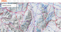
I prefer to use Strava for most of my detailed route planning because it gives the option of viewing a Global Heatmap of cycling that shows which roads in a region are used most often by cyclists (see the image on the right). The data is normally dominated by local cyclists and so it gives access to local knowledge about what the best options are. When using Strava’s route planner, the heat map can be toggled on and off in the Map Settings panel on the right, or you can view the heat map without a Strava account by going directly to this page. Obviously, the heat map information must be combined with other information about the status of each road and your personal preferences.
It’s generally best to avoid asking routing software or your navigation device for a route designed for “cycling.” That tends to give extremely slow and convoluted routes on roads and trails of various quality, which are generally very inefficient and not the type of thing that you want to use during a race. Some people have quit a race because they have been so frustrated with following such routes and being unable to plan better options on their own.
If you plot a route by just clicking on the roads that you chose in your rough planning stage and allow the software to decide how to connect the roads together then it may take some very odd shortcuts through fields or decide to take a long detour to avoid a certain stretch of road. I therefore zoom in to view a very high level of detail and make sure that every single piece of road plotted, even sections that are just a few hundred meters long, are exactly what I want to use.
Mapping software sometimes refuses to let you use a certain stretch of road. You should first check that cycling is permitted on that road (see below) and if it is then you can use a manual routing mode to just draw straight lines between points to get through that section, and then turn the regular routing back on that makes the line follow the road automatically. A helpful post was made on the TCR Facebook Group concerning how mapping sites determine road surfaces.
Prohibited Roads & Tunnels
Race rules state that you must follow all local laws, which includes not using roads where cycling is forbidden. In most places, knowing which roads you can use is quite easy because only roads clearly marked as motorways are not allowed. Unfortunately, it is not always that simple. There are occasionally tunnels in the mountains that cyclists are not allowed through and there are occasionally major roads that are not officially motorways on which cyclists are banned. In addition, sometimes when no other option exists in the region, cyclists are officially allowed to use a motorway (although this is very rare). Knowing about the legality of every road in your route beforehand is therefore extremely difficult.
Volunteer dot watchers are assigned to keep an eye on the tracks of a few riders each during the race, and one of the things that they will be looking for is the legality of the roads being used. The organizers may also check the tracker data after the race is finished to control certain sections of the route even closer.
In many cases, it can be debated whether a prohibited road is more or less dangerous to cycle on than an alternative road. However, the race organizers must forbid racers from using these roads for several reasons: First, if the local authorities know that many racers are using a prohibited road then they may not allow the race to visit the region in the future. Second, if an accident happened on a prohibited road and the race organizers were not doing anything to forbid racers using such roads then the organizers could be seen as somewhat liable. There is therefore no debate that such roads should be forbidden to racers and the only way to enforce this is to give time penalties to people who use such roads.
Licensed under CC BY 3.0
You should therefore spend some time checking any questionable roads on your proposed route. There are several ways to do this, none of which are perfectly reliable. Any road that is designated to be a motorway, and so cycling is forbidden, should be colored differently on paper and online maps, but sometimes the place where a roads changes from being a motorway to a regular road and vice versa is not clearly or accurately shown. Another method is to use Google Street View, which covers most major roads in Europe, but not all. When looking at a region on Google Maps, you can drag the little yellow man in the bottom-right hand corner onto the map and place him at the entrance to a road or tunnel that you want to investigate to see whether there are any No Cycling signs. You can rotate the view and move backwards and forwards along the road by clicking on the arrows that appear in the image and use the map in the bottom-left to check that you are in the correct place.
Google Street View is also not a perfectly reliable method of determining which roads are prohibited, so another tool is the Strava Global Heatmap that is described above. If that map shows very few cyclists using a certain main road and many using another option then you can infer that the main road is forbidden to cyclists. Unfortunately, the heat map may sometimes show many cyclists using a road that is officially forbidden, but that many local riders use and which is tolerated by the local authorities. It would be difficult for the race organizers to treat these differently from other forbidden roads, so you still need to avoid them.
These methods are therefore far from perfect, so if you are still unsure about a certain section of road and it is really important for your route then you could try to contact local riders or the authorities beforehand to determine it’s official status. You should also make a backup plan that you can use in case you arrive and find that the road is prohibited to cyclists. If there are no alternative roads in the region, your confidence about being allowed to use a road is not very high, and you prefer to be conservative then you may consider using another route entirely instead of risking losing a lot of time due to making a diversion or receiving a time penalty.
The Transcontinental Race has occasionally decided that certain roads that cyclists are officially allowed to use are too dangerous and risky, and so have banned their use by all racers. Make sure that you are aware of where these are even if they are not on your planned route because you may change your plan while on the road and there will be nothing on the road showing that you shouldn’t use these sections.
Route Recon’ Rides – Real & Virtual
Nothing beats actually riding some of the race route. You can learn which sections will be the most difficult, where to find services, whether there are better road options available, and generally become more comfortable and familiar with your route. Some people believe that riding some of the route beforehand goes against the spirit of adventure of the race, but I view things differently and prefer to be as prepared as possible, so for me route recon’ rides are a fun part of my preparation and I highly recommend doing them if you have the opportunity. Such rides can also provide an excellent test of your equipment and navigation strategy whilst also giving you some good physical training in a motivating setting (see also the Multi-Day Training Rides page).
I’m very fortunate because I live in Switzerland and so I’ve done several training weekends that started and finished by taking a high-speed train for a few hours to and from points close to my proposed race route. When choosing which sections to preview I often choose to go to the regions that I’m least familiar with, where I’ll have to navigate through a major city, or parts where it’s difficult to choose which of two route options to take.
Other people choose to do route recon’ rides in the most mountainous and difficult portion of the route because that is the kind of riding that they are least familiar with. One problem can then be timing the trip so that the high passes are open because many don’t open until May or June. To find out which passes should be open, many paper maps show a box next to the pass with Roman numerals that shows the typical closing months; for instance [XI-V] would mean that the pass is closed from November (XI = 11) until May (V = 5). However, the opening dates can vary by a few weeks depending on how much snow fell during the winter, so for more up-to-date information you can visit the sport-passion.fr website that shows the major French Cols, and for Switzerland the TCS website (click on the Cols checkbox on the left-hand side of the map). I don’t know about such resources for other countries (please let me know if you do).

The next best thing to actually riding the route is to virtually ride it. As mentioned above, Google Street View covers most roads in western Europe and some in eastern Europe. You can therefore do a virtual ride through a town or village to discover if there is a grocery store, restaurant, hotel, gas station, bike shop, etc. It can also be useful to asses how busy, wide, and pleasant the roads might be to ride on.
Last significant page update: November, 2016
This page is in the Mental Approach & Strategy section. The next page in this section is: